


Authors: Stine Lines, Kjersti Boge Christensen and Bjarte Fagerås, GCE Ocean Technology
Reach Subsea is pioneering a new and innovative source of data with application to earthquake hazard and risk reduction.

Earthquakes have long captured our fascination and fear, shaking the ground beneath our feet and reshaping landscapes in an instant. Vast resources are invested to increase understanding of the processes leading up to earthquakes. Accurately predicting the extent of these powerful tremors is critical to save lives and protect communities.
Predicting accurately
The most destructive earthquakes on Earth occur at great ocean depths where two plates meet, and one plate is gradually pushed under the other. Examples of such areas are the western coast of North America and the eastern coast of Japan. The enormous earthquakes occur because irregularities in the surface of the descending plate prevent free movement and cause locked zones where the plate’s motion energy gradually builds until one day, the forces become so great in the entire area that they loosen. The Tohoku earthquake in Japan in 2011 is an example of such an earthquake. This earthquake was more powerful than the models at the time predicted and is an example of how things can go wrong when you lack information to implement sufficient protection of critical infrastructure, such as the Fukushima nuclear power plant.

Unveiling the mechanics of earthquakes
Developing accurate earthquake models necessitate a profound understanding of complex geological phenomena. To peer into the depths of structures many kilometres beneath the ocean floor, scientists predominantly must rely on indirect measurements, with seismic techniques leading the charge.
Norway is at the forefront of implementing new subsurface measurement technologies within the offshore oil and gas industry. One of the most promising advancements is seafloor microgravimetry – a technique that measures subtle changes in the gravitational field in the gas-producing fields. This data offers insights into the shifting subsurface masses and the fluid flow through formations during production, a key area of expertise for Reach Subsea.

A fruitful partnership between science and innovation
Reach Subsea joined forces with the University of Bergen and was introduced to one of the unresolved questions in earthquake research: how slow earthquake activity in subduction zones affects the stress buildup and subsequent rupture extent of megathrust earthquakes. The idea is that by mapping fluid flow related to slow earthquakes, a deeper understanding of the stress buildup in the faults of the subduction zone is obtained, providing new insights into earthquake research in the area.
This led to an introduction to the Japan Agency for Marine-Earth Science and Technology, JAMSTEC, which recognized the potential of microgravimetry as a datatype that could enhance their earthquake monitoring program.
JAMSTEC has been investigating the estimation of the vertical seafloor deformation using online seafloor pressure sensors deployed at multiple points. They expect that the integrated analysis by comparison between pressure and gravity measurements will contribute to the development of precise earthquake modelling.

Dr Toshiya Fujiwara from JAMSTEC speaks highly of the project’s value:
Accurate seafloor gravity observation is an area in which JAMSTEC is lacking. Given that the same accuracy can be obtained in observations of natural phenomena, I am very interested in the possibility of observing temporal mass changes associated with subsurface fluid movement in subduction zones by applying the techniques and methods developed in monitoring submarine oil and gas fields.
Dr Thoshiya Fujiwara, JAMSTEC
Looking beyond the horizon, the potential of microgravimetry as a data source for earthquake hazard and risk reduction extends to regions worldwide, especially in coastlines with densely populated areas.
In these high-risk zones, where mega earthquakes have been devastating, improving the models to predict the extent of the seismic events more accurately can be crucial to minimizing damage, says Martha Lien from Reach Subsea.
Martha Lien, Environmental Monitoring Director
Reach Subsea
Reach Subsea’s cutting-edge technology offers a new potential source of information in addressing this critical challenge, exemplifying the positive outcomes that can emerge from the fusion of scientific innovation and collaborative partnerships.
Contact Information
GCE Ocean contact:
Bjarte Fagerås
Reach Subsea contacts:
Martha Lien, Environmental Monitoring Director
Leon Løvheim, Managing Director Monitoring Division
About the project
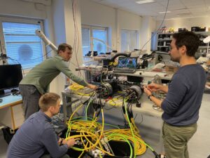
The ASUMO project started in June 2018 after confirmation of support from Innovation Norway. The project is led by Reach Subsea with the University of Bergen (UiB) and Japan Agency for Marine-Earth Science and Technology (JAMSTEC) as pilot customers. Reach Subsea, in cooperation with JAMSTEC and UiB, has developed instrumentation rated to 5000 m water depths that may contribute to a better understanding of processes leading up to earthquakes and tsunamis.
For more information on the technology: